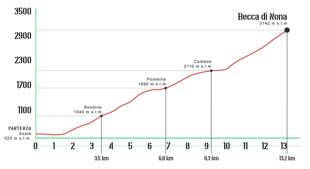
12in Edition
13 km / 2,500 m
Maximum time: 4 hours
N. of participants: 500

SEE YOU IN 2024

Gps

The following is certified as an official
VERTICAL KILOMETER® COURSE

The route winds between the municipalities of Aosta and Charvensod. The departure is located in Chanoux Square in the centre of Aosta. The first 1000m are flat but after the roundabout of the Pont Suaz begins the ascent that in a few hundred meters takes the athletes to the capital of Charvensod (750m). After passing the village you leave the asphalt permanently to take the steep paths that cross the forest connect the pastures. Arriving in the beautiful valley of Comboé (2100m.) turn left, leaving the shadow of the pines for the last 1000m of altitude that lead to the top of the Becca di Nona (3142m) from where you can enjoy a beautiful 360-degree view of the Valdostane mountains.


Aosta - Comboé elevation profile

Re-entry

Once at the summit the athletes of Aosta – Becca di Nona will descend to Comboé using a specially marked path that, in the first part, is different from the climb. In Comboé you can breathe thanks to the refreshment point where there will also be the traditional musical accompaniment of the 'Comboé Band'. Then we will continue towards Pila (Gressan) from where in twenty minutes by cable car you can reach Aosta.
N.B.: Please note that in order to take advantage of free access to the cable car it is necessary to show the bracelet provided at the time of collection of the bib.

TOP