
3in Edition
Maximum time: 5 hours
SEE YOU IN 2026
3in Edition
Maximum time: 5 hours
SEE YOU IN 2026
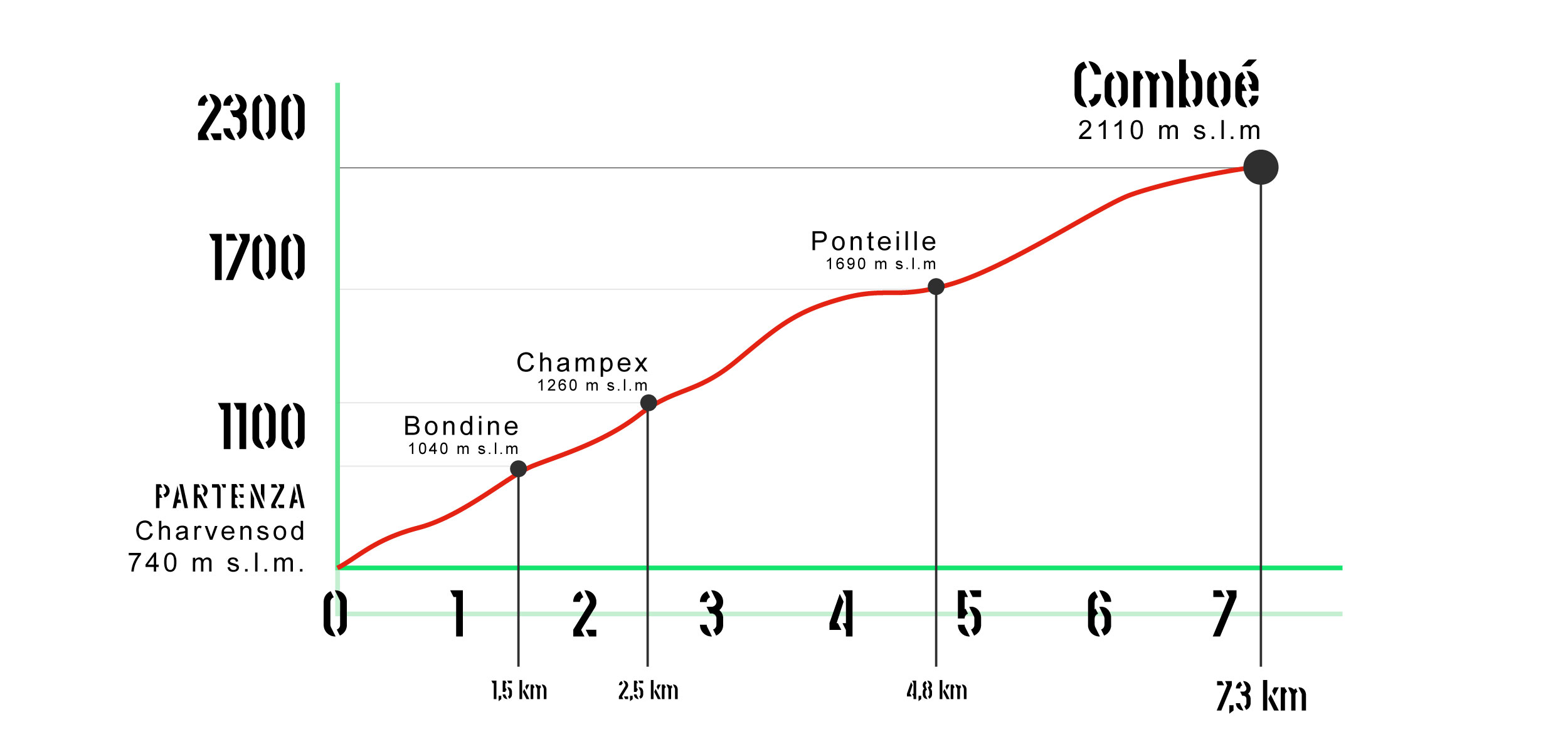
A bit of a challenging walk! This is how La Montée des Gourmands can be defined, a walk starting from the historic center of Charvensod and arriving in the magnificent valley of Comboé (mt. 2110). Every 300 meters of elevation gain, participants will be able to rest and recharge their batteries in 6 different food and wine points where they can taste various products of Aosta Valley origin selected by the Coop Cofruits Society. The route will start in the locality of Chef-lieu in the municipality of Charvensod where participants will be able to do breakfast enjoying a good coffee accompanied by shortbread, torcetti and chocolate.
The second stage will take place in Bondine where one will be served snack Composed of: apple and blueberry juice, jams, black bread, strawberries and yogurt. Once you reach the hamlet of Le Champex You will be able to taste the flavors of theAma Potager characterized by vegetables, fresh cheeses and pickled vegetables, all accompanied by apple juice and a Rosé wine. Continuing the walk you will arrive at Ponteille for theAspero de la Boucherie, made with cured meats and honey. Once you arrive at the valley of Comboé, there will be two refreshment points: the first Aperò Fromage, consisting of a small set of cheeses with various sauces and jams, while at the second point the lunch, made with polenta and sausage.

And that's not all: along the entire route there will be various folklore and musical groups to animate the party. Once you arrive at the Comboé valley, the notes of the Orage will welcome you and keep you company for the last stage.
The Montée des Gourmands is an event that allows you to combine sport, nature, good food, celebration and joy in a new formula of knowledge and promotion of the territory.
Atleti e simpatizzanti vi aspettiamo!
")


![]() Becca di nona 3142 a.s.d.
Becca di nona 3142 a.s.d.
Località Capoluogo, 1
11020 Charvensod
91067570076 / 01208960078
Crafted with ♥ by Roberto Roux © 2020 Becca di Nona 3142 All rights reserved.


